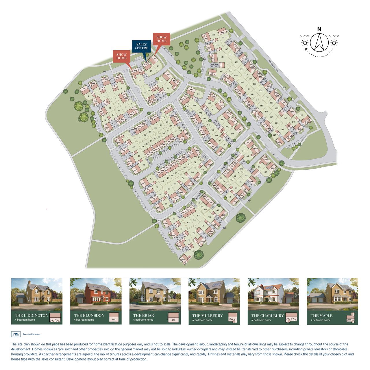
Woodlands is our charming collection of new build homes near Swindon. Enjoy a rural yet connected lifestyle in the Wiltshire village of South Marston.
The new houses for sale come with open-plan spaces for sociable living, as well as ample parking and EV charging points. Other energy-efficient features, such as solar panels, have been built into the design so you can embrace a more sustainable approach to running your home.
Read more about Woodlands
READ MORE
This exciting new development has plenty of green space and wildflower meadows, creating a delightful environment to sit, relax and enjoy. There are also plans for a primary school and pre-school – perfect for growing families.
The village offers a choice of pubs to enjoy locally and for a weekly grocery shop there are supermarkets within a short drive.
Woodlands offers great connectivity to Swindon and the surrounding areas with the A420 and A419 commuter routes and the M4 for Bristol close by. Swindon train station offers easy access to London, Bath and Bristol in less than an hour.
New houses set in the beautiful Wiltshire village of South Marston, near Swindon.
Purchase schemes available to suit your needs, including Home Exchange, Smooth Move & Key Worker
Modern 4-bedroom new build homes with stunning open-plan layouts.
An exciting new community with green space, public footpaths and plans for a local school.
Enjoy peace of mind with a 5-star rated home builder.
Buy with confidence thanks to a 10-year warranty on our new build homes.
Energy-efficient designs to help you save money and embrace eco-friendly technology.
Every home listed here today, and the homes that left the listings in the last year.
For sale
5
Reserved or sold STC
1
Median price
£567,500
Median per sq ft
£335
Median time listed
13 days
Left the listings this year
8
Where the prices sitEach home by its price, in rows by bedrooms
4 bed
£480K£500K£520K£540K£560K£580K£600K
How fast it is sellingHomes a month, the last year
Listed, above the lineLeft the listings, below the line
1050510
From the homes listed with HomePortfolio and on Bovis Homes’s own site. A home that left the listings was most likely reserved or sold; a builder does not say which.
Walk ScoreCar-dependentWalk Score 11 out of 100: Car-dependent
Transit ScoreMinimal transitTransit Score 7 out of 100: Minimal transit
Bike ScoreSomewhat bikeableBike Score 44 out of 100: Somewhat bikeable
Broadband
0 networks
older homes nearby: up to 1 Mbps
Flood risk
Very low
rivers and the sea
Crime
Above the area
161.7 vs 84.9 a year per 1,000
Typical pay in Swindon
£33,135
median for employees living in Swindon, ONS 2025: the council's figure, not this neighbourhood's
Schools
The nearest open schools within 2 km, with their current Ofsted outcome.
3 nearest67%33%
Good or better2
Improvement needed0
Serious concerns0
No grade yet1
480 m6 min walkSouth Marston Church of England Primary SchoolPrimary · Academy converter, 480 m awayIts predecessor, South Marston Church of England Primary School, was rated Good on 21 Feb 2013Not yet inspected
How many of each are within 1.6 km, and the walk to the nearest.
6 places to eatThe Royal Oak Bishopstone, 120 m2 min
4 pubsCarpenters Arms, 560 m7 min
3 parksSouth Marston Park, 460 m6 min
People and households
The neighbourhood around it (Swindon 008A) against Swindon as a whole.
People
1,930
Households
765
In good or very good health
85% vs 83%
Age profileShare of everyone in each five-year band
This neighbourhoodSwindon
10%5%0%
Getting around
How far everyday errands, public transport and cycling go from here, and how people here travel to work.
WalkCar-dependent
TransitMinimal transit
BikeSomewhat bikeable
Almost all errands require a car.
Getting to work
This neighbourhood41%53%
Swindon31%
Broadband and mobile
What the 6 homes within 150 m record: a new home is usually served by the same networks.
Broadband
No full-fibre-only network recorded
DecentSuperfastUltrafastGigabit
1101001K
New homes in England must be built gigabit-ready (Building Regulations Part R, for work begun from 26 Dec 2022), with a gigabit connection where one can be had within a £2,000 cost cap. The speeds here are what the existing homes around it record: ask the sales office which network will serve the home.
Mobile signal
Network
Calls indoors
Data indoors
Data outdoors
EE
Limited
Limited
Likely
O2
Limited
Limited
Risks
Flooding, radon, ground, noise and air at this spot.
Flooding from rivers and the seaLowVery lowEvery one of the 2 addresses around it is in the very low band.
Flooding from surface waterLowLowOf the 2 addresses around it: 1 low, 1 very low.
RadonModerate3 to 5% of homes above the action levelHomes here should be tested; new homes in such areas are built with radon protection.
Ground stabilityLowLow landslide susceptibilityFrom the British Geological Survey’s landslide map of the area.
NoiseLowRoad 42 dB, rail up to 44 dBRoad is the typical daytime level at the homes around it, the middle of their readings; rail is the loudest of them, since a line is heard by every home beside it. 55 dB is a busy street; WHO advises under 53 dB for roads and 54 dB for railways.
Crime
Police-recorded crime in the neighbourhood, December 2025 to September 2026, against Swindon.
161.7crimes a year per 1,000 residentsAbove Swindon at 84.9260 recorded in 10 months
Month by monthCrimes per 1,000 residents
This neighbourhoodSwindon
3020100
Planning nearby
Applications within 500 m in the last 3 years: when each was made and how it went, the larger schemes listed first.
66 applications
58 approved
7 awaiting decision
1 withdrawn
Approved
Sold nearby
Homes sold within 1 km in the last two years, new build and resale.
Median resale
£485,000
Median new build
None
Sales
23 0 new, 23 resale
Every salePrice paid, by the date it completed
New buildResaleMedian resale
£1M£800K£600K£400K£200K£0
£485K
Primary · Academy converter, 1.1 miles away · inspected 28 Jun 2023
Good
1.1 milesGrange Junior SchoolPrimary · Academy sponsor led, 1.1 miles away · inspected 23 May 2023Good
Ofsted and Get Information about Schools, via HomePortfolio.
2 supermarkets and groceriesSPAR Euro Garages South Marston, 620 m
8 min
1 stationStratton Park Halt railway station, 0.9 miles19 min
Overture Maps places, via HomePortfolio.
01020304050607080
Show the figures
Age profile
Age
This neighbourhood
Swindon
0 to 4
4%
6%
5 to 9
5%
6%
10 to 14
5%
6%
15 to 19
5%
5%
20 to 24
4%
5%
25 to 29
4%
7%
30 to 34
6%
7%
35 to 39
6%
7%
40 to 44
5%
7%
45 to 49
7%
7%
50 to 54
9%
7%
55 to 59
8%
7%
60 to 64
7%
6%
65 to 69
7%
5%
70 to 74
6%
4%
75 to 79
5%
3%
80 to 84
3%
2%
85 and over
3%
2%
Households
This neighbourhood73%20%
Swindon65%28%
Families73% vs 65%
One person20% vs 28%
Other households7% vs 7%
Homes are
This neighbourhood42%38%
Swindon29%34%16%19%
Owned outright42% vs 29%
Owned with a mortgage38% vs 34%
Shared ownership2% vs 1%
Socially rented8% vs 16%
Privately rented10% vs 19%
Adults are
This neighbourhood61%28%
Swindon63%19%11%
In work61% vs 63%
Retired28% vs 19%
Students3% vs 4%
Looking for work1% vs 3%
Caring, sick or other8% vs 11%
Highest qualification
This neighbourhood32%19%24%14%
Swindon28%16%29%17%
Degree or higher32% vs 28%
A levels19% vs 16%
GCSEs24% vs 29%
Apprenticeship7% vs 6%
None
Cars per household
This neighbourhood30%63%
Swindon19%42%39%
None7% vs 19%
One30% vs 42%
Two or more63% vs 39%
ONS Census 2021 and ONS pay by council (ASHE), via HomePortfolio.
53%
Work from home41% vs 31%
Drive53% vs 53%
Bus, train or tube1% vs 6%
Walk or cycle4% vs 9%
Nearest station Stratton Park Halt railway station 0.9 miles, 19 min walk
Walk Score® (walkscore.com), ONS Census 2021 and Overture Maps places, via HomePortfolio.
Likely
Three
Limited
Limited
Likely
Vodafone
Limited
Limited
Likely
Ofcom Connected Nations, via HomePortfolio. Ofcom copyright.
Air qualityModerate
Nitrogen dioxide 7.3, PM2.5 6.5, PM10 11.3
Above the WHO guideline for PM2.5 (2024, µg/m³).
Air quality, 2024
Nitrogen dioxide7.3 µg/m³ · within the guideline
WHO 10
PM2.56.5 µg/m³ · 1.3 times the guideline
WHO 5
PM1011.3 µg/m³ · within the guideline
WHO 15
Daytime noise
Road, typical home42 dB · within WHO’s level
WHO 53
Rail, loudest home44 dB · within WHO’s level
WHO 54
Environment Agency NaFRA2, BGS and UKHSA radon, BGS GeoSure, Defra noise mapping and Pollution Climate Mapping, via HomePortfolio.
10.9
DecMarJunSep
September 2026: 21 crimes here, 10.88 per 1,000: Swindon: 6.83 per 1,000
Show the figures
Crime month by month
Month
Crimes here
Per 1,000 here
Per 1,000 across Swindon
December 2025
19
9.84
6.6
January 2026
22
11.4
6.86
February 2026
15
7.77
6.66
March 2026
18
9.33
7.65
April 2026
30
15.54
7.5
May 2026
30
15.54
6.86
June 2026
31
16.06
6.47
July 2026
32
16.58
7.74
August 2026
42
21.76
7.59
September 2026
21
10.88
6.83
Most recordedIn the neighbourhood, 10 months
Violence and sexual offences99
Public order52
Criminal damage and arson26
Anti-social behaviour18
Drugs14
data.police.uk, via HomePortfolio. Crimes are mapped to an approximate location.
Awaiting decision
Refused
Withdrawn
Oct2025AprJulOct2026AprJulOct
ApprovedLarge scheme260 mDischarge of Condition(47) Noise from previous application S/OUT/13/1555-Outline Planning Permission, for a sustainable urban extension to the east of Swindon and north of the A420 of up to 2,380 dwellings together with a mixed use local centres/areas (including A1 retail up to 1,500 sq metres, services (A2), restaurants, pubs and takeaways (A3, A4, A5), business uses (B1) up to 1,000 sq metres, residential); community uses (D1); sheltered and/or care accommodation (C2/C3); two primary schools; green infrastructure including formal (including playing fields) and informal open space, landscape, biodiversity and amenity space; play space (including NEAPS/LEAPS/MUGAS); changing and sports facilities (including D2) and ancillary retail uses; sustainable drainage systems; highway, cycle and pedestrian routes; car parking; infrastructure (including utilities); engineering works including ground remodelling; demolition, site reclamation and removal of structures; the formation of new accesses from the A420, Old Vicarage Lane and Thornhill Road.Made 10 Apr 2026 · decided 12 May 2026 · S/COND/26/0477
ApprovedLarge scheme270 mReserved matters application (access, appearance, layout, scale and landscaping) for 122 dwellings and associated infrastructure -Reserved Matters from previous outline permission S/OUT/13/1555.Made 27 Oct 2025 · decided 1 Apr 2026 · S/RES/25/1389
ApprovedLarge scheme310 mDischarge of Conditions (2) Facing Materials (3) Surface Materials (5) Means of Enclosure from previous application S/RES/24/0947 - A reserved matters application (access, appearance, layout, scale and landscaping) for 137 dwellings and associated infrastructure - Reserved Matters from previous outline permission S/OUT/13/1555.Made 4 Aug 2025 · decided 4 Feb 2026 · S/COND/25/0974
ApprovedLarge scheme310 mPartial Discharge of Conditions (36) Construction Method Statement (37) Construction & Environmental Management Plan (61) Broadband from previous application S/OUT/13/1555 - Outline Planning Permission, for a sustainable urban extension to the east of Swindon and north of the A420 of up to 2,380 dwellings together with a mixed use local centres/areas (including A1 retail up to 1,500 sq metres, services (A2), restaurants, pubs and takeaways (A3, A4, A5), business uses (B1) up to 1,000 sq metres, residential); community uses (D1); sheltered and/or care accommodation (C2/C3); two primary schools; green infrastructure including formal (including playing fields) and informal open space, landscape, biodiversity and amenity space; play space (including NEAPS/LEAPS/MUGAS); changing and sports facilities (including D2) and ancillary retail uses; sustainable drainage systems; highway, cycle and pedestrian routes; car parking; infrastructure (including utilities); engineering works including ground remodelling; demolition, site reclamation and removal of structures; the formation of new accesses from the A420, Old Vicarage Lane and Thornhill Road.Made 8 Jul 2025 · decided 4 Feb 2026 · S/COND/25/0852
ApprovedLarge scheme490 mPartial Discharge of Condition (10) FLEAMP from previous application S/OUT/13/1555 - Outline Planning Permission, for a sustainable urban extension to the east of Swindon and north of the A420 of up to 2,380 dwellings together with a mixed use local centres/areas (including A1 retail up to 1,500 sq metres, services (A2), restaurants, pubs and takeaways (A3, A4, A5), business uses (B1) up to 1,000 sq metres, residential); community uses (D1); sheltered and/or care accommodation (C2/C3); two primary schools; green infrastructure including formal (including playing fields) and informal open space, landscape, biodiversity and amenity space; play space (including NEAPS/LEAPS/MUGAS); changing and sports facilities (including D2) and ancillary retail uses; sustainable drainage systems; highway, cycle and pedestrian routes; car parking; infrastructure (including utilities); engineering works including ground remodelling; demolition, site reclamation and removal of structures; the formation of new accesses from the A420, Old Vicarage Lane and Thornhill Road.Made 8 Jul 2025 · decided 2 Sept 2025 · S/COND/25/0854
ApprovedLarge scheme490 mPartial Discharge of Condition 9 - Character Area Design Code from previous application S/OUT/13/1555 - Outline Planning Permission, for a sustainable urban extension to the east of Swindon and north of the A420 of up to 2,380 dwellings together with a mixed use local centres/areas (including A1 retail up to 1,500 sq metres, services (A2), restaurants, pubs and takeaways (A3, A4, A5), business uses (B1) up to 1,000 sq metres, residential); community uses (D1); sheltered and/or care accommodation (C2/C3); two primary schools; green infrastructure including formal (including playing fields) and informal open space, landscape, biodiversity and amenity space; play space (including NEAPS/LEAPS/MUGAS); changing and sports facilities (including D2) and ancillary retail uses; sustainable drainage systems; highway, cycle and pedestrian routes; car parking; infrastructure (including utilities); engineering works including ground remodelling; demolition, site reclamation and removal of structures; the formation of new accesses from the A420, Old Vicarage Lane and Thornhill Road.Made 23 May 2025 · decided 3 Sept 2025 · S/COND/25/0650
Local planning authorities’ registers, via HomePortfolio.
2025AprJulOct2026AprJul
Show the figures
Homes sold nearby
Price
Home
Sold
Distance
£712,500
Detached · resale · 200 m²
21 Jul 2026
290 m
£320,000
Semi-detached · resale · 76 m²
26 Jun 2026
250 m
£270,000
Terraced · resale · 69 m²
18 May 2026
320 m
£400,000
Terraced · resale · 132 m²
10 Apr 2026
730 m
£525,000
Semi-detached · resale · 130 m²
6 Jan 2026
380 m
£695,000
Detached · resale · 246 m²
18 Dec 2025
450 m
£175,000
Terraced · resale · 91 m²
4 Dec 2025
570 m
£299,000
Terraced · resale · 71 m²
28 Nov 2025
590 m
£245,000
Semi-detached · resale · 83 m²
27 Nov 2025
740 m
£245,000
Detached · resale · 56 m²
10 Nov 2025
740 m
£550,000
Detached · resale · 138 m²
15 Aug 2025
490 m
£485,000
Detached · resale · 726 m²
4 Aug 2025
370 m
£765,000
Detached · resale · 194 m²
4 Aug 2025
490 m
£270,000
Semi-detached · resale · 69 m²
29 Jul 2025
290 m
£350,000
Terraced · resale · 90 m²
7 May 2025
730 m
£660,000
Detached · resale · 222 m²
16 Apr 2025
530 m
£395,000
Detached · resale · 110 m²
27 Mar 2025
290 m
£485,000
Detached · resale · 149 m²
27 Mar 2025
370 m
£650,000
Detached · resale · 152 m²
21 Mar 2025
330 m
£580,000
Detached · resale · 138 m²
20 Dec 2024
610 m
£850,000
Detached · resale · 168 m²
19 Dec 2024
500 m
£558,500
Detached · resale · 142 m²
13 Dec 2024
430 m
£438,000
Detached · resale · 117 m²
11 Dec 2024
280 m
HM Land Registry Price Paid with EPC floor areas, via HomePortfolio.


 Built by Bovis Homes